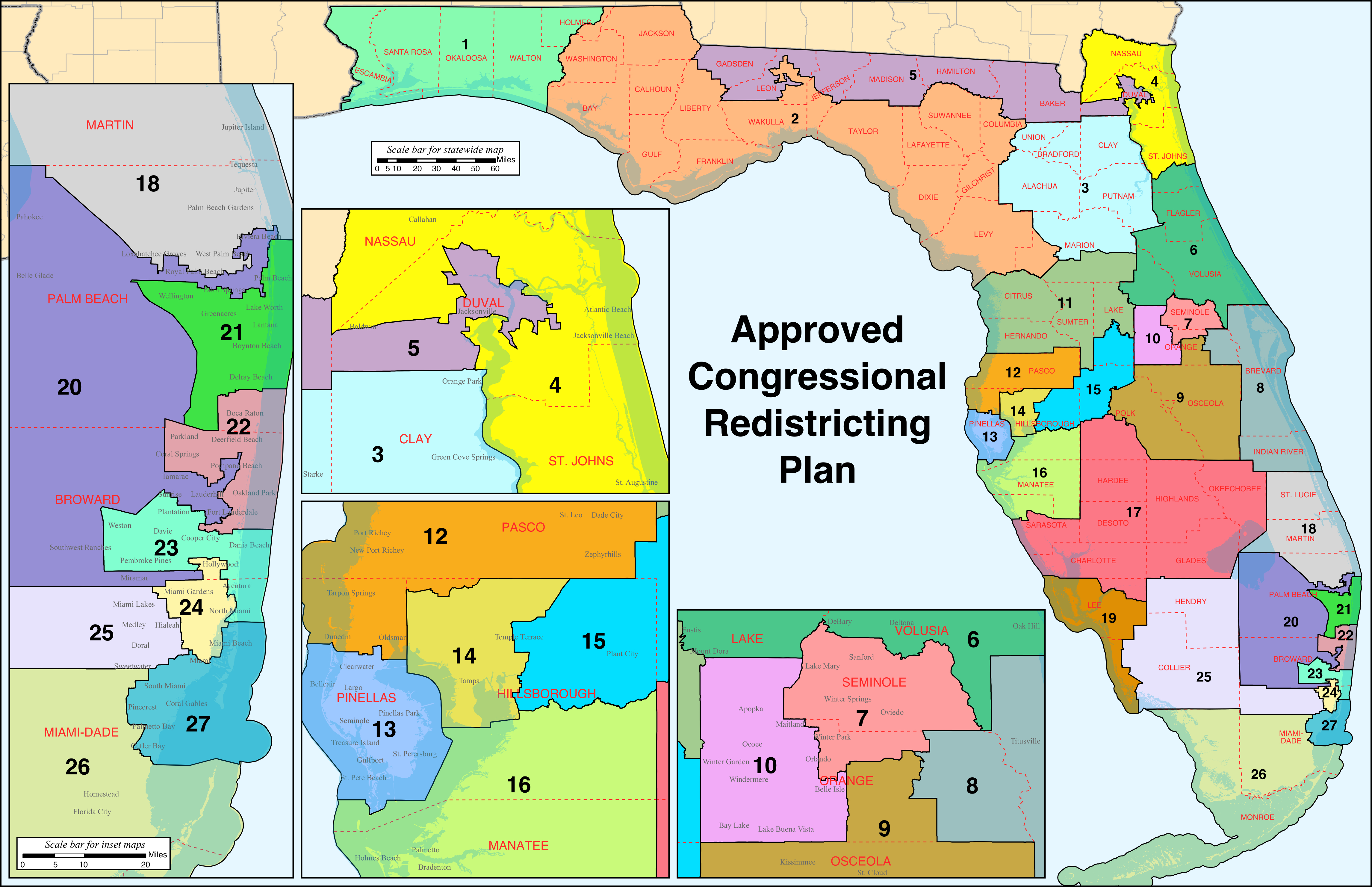
Maps define power. In Florida, they also define lawsuits, long nights in Tallahassee, and a whole lot of confusion for the average voter just trying to figure out who represents them. If you’re looking at the Florida 6th congressional district map, you’re looking at a slice of the Sunshine State that has undergone a massive transformation over the last few years. It’s not just about lines on a GPS. It’s about how Northeast and Central Florida’s political identity is being carved up.
Basically, the 6th District is the "Surf and Turf" of Florida politics.
You’ve got the coastal vibes of Volusia County—think Daytona Beach and the Speedway—mixed with the rapidly growing suburban and rural stretches of Lake, Marion, and even parts of Putnam. But here’s the thing: if you haven't checked the boundaries since 2020, you’re probably looking at the wrong map. The redistricting cycle following the 2020 Census didn't just tweak the edges; it fundamentally shifted the center of gravity for this seat.
The Big Shift: From the Coast to the Interior
For a long time, the 6th was seen primarily as a coastal district. You thought of St. Augustine. You thought of the Atlantic. But the current Florida 6th congressional district map tells a different story.
During the 2022 redistricting process—which was, honestly, a chaotic saga involving Governor Ron DeSantis’s office and the Florida Legislature—the 6th was pushed further south and west. It lost the historic charm of St. Johns County and the city of St. Augustine to the 4th and 7th districts. In exchange, it swallowed more of the inland areas.
Now, the district is anchored heavily in Volusia County. Most of the population lives there. But it also stretches its arms out to grab the eastern portions of Marion County (including parts of Ocala) and a significant chunk of Lake County. This changed the math. It moved the district from being a "competitive-leaning Republican" seat to a "solidly Republican" stronghold.
Why does this happen? Population growth. Florida added over 2.7 million people between 2010 and 2020. That’s like adding a whole new city every few months. When that many people move in, the old maps basically melt. The 6th had to shrink geographically in some areas because the population density in places like Daytona Beach and Port Orange surged.
Who Lives Here Now?
The demographics of the Florida 6th congressional district map are a fascinating mix. You have the "Snowbirds" and retirees who have flocked to the master-planned communities in Lake and Volusia. Then you have the legacy agricultural families in Marion and Putnam who have been there for generations.
- Volusia County: The heart of the district. It contains Daytona Beach, Ormond Beach, and DeLand.
- Marion County: The eastern side of the county, known for its horse farms and the Ocala National Forest, is now a key part of the 6th.
- Lake County: This is where the suburban sprawl is hitting hardest.
- Putnam County: Just a tiny sliver, but it adds a very rural, "Old Florida" feel to the northern boundary.
It’s a district of contrasts. You can go from a high-tech aerospace firm near the Cape to a cattle ranch in under an hour without ever leaving the district lines.
The Politics of the Lines
Let's be real. Redistricting is rarely just about making sure every district has roughly 769,000 people. It’s about partisan advantage. The current Florida 6th congressional district map was a product of the controversial "DeSantis Map."
Earlier versions proposed by the State Senate were much more modest. They kept things mostly the same. But the Governor’s office pushed for a more aggressive realignment of Florida's 28 districts. The result for the 6th was a map that effectively packed more Republican-leaning voters into a single area.
Michael McDonald, a University of Florida professor and redistricting expert, has often pointed out that Florida’s map-making process is unique because of the "Fair Districts" amendment in the state constitution. Voters passed this to prevent gerrymandering. However, the legal battles over the current map suggest that "fair" is very much in the eye of the beholder.
The 6th District is currently represented by Michael Waltz, a combat veteran and the first Green Beret elected to Congress. The map was drawn in a way that makes his seat incredibly secure. In the old 6th, a Democrat might have had a puncher's chance if the national mood was just right. In this version? It’s a steep, nearly impossible hill to climb for the opposition.
Understanding the "Ghost" Borders
Sometimes you’ll see maps online that still show the 6th going all the way up to the Georgia border or including Jacksonville suburbs. Those are ghosts of the past.
Modern mapping software like Dave’s Redistricting or the official Florida Redistricting website shows the precise jagged edges. For example, if you live in Ocala, you might be in the 6th, or you might be in the 3rd or the 11th. It literally comes down to which side of the street you live on in some neighborhoods.
This creates a "representation gap." People often call the wrong congressional office because they remember where the lines used to be. If you’re in the 6th now, your focus is likely on things like Everglades restoration, coastal erosion in Volusia, and the massive infrastructure needs of the I-4 corridor.
The Economic Engine Within the 6th
The Florida 6th congressional district map isn't just a political tool; it's an economic blueprint.
- Tourism and Events: The district houses the Daytona International Speedway. This isn't just a racetrack; it’s an economic nuke that goes off every February and August, bringing in hundreds of millions of dollars.
- Higher Education: Embry-Riddle Aeronautical University and Bethune-Cookman University are major hubs in the district. They drive tech and aviation jobs.
- Logistics: Because the district straddles I-95 and sits near the I-4 junction, it’s becoming a warehouse and distribution mecca.
- Agriculture: Head west toward Marion County on the map, and the economy shifts to timber and thoroughbred horses.
When the map changed, the federal priorities changed too. A representative for the 6th now has to balance the needs of a hospitality worker in Daytona with a citrus grower in Lake County. It’s a weird, difficult balancing act.
Why the Map Might Change Again
Nothing in Florida politics is permanent.
There is ongoing litigation regarding Florida's congressional maps. While much of the focus has been on North Florida's 5th District and its impact on Black voters, the entire map is often treated as a "house of cards." If a court orders one district to be redrawn, it creates a ripple effect.
If the 5th District is altered, the 4th must change. If the 4th changes, the 6th must move to accommodate those bodies. It’s a giant jigsaw puzzle where the pieces are made of jelly.
For now, the Florida 6th congressional district map stands as it was drawn in 2022. But keep an eye on the Florida Supreme Court. Their rulings on redistricting standards will determine if these lines hold through the 2028 election or if we’ll be looking at a new version by 2026.
Actionable Steps for Residents
If you’re trying to navigate this or just want to be an informed citizen, don’t just trust a static image you found on Google Images.
- Check your voter registration card. Seriously. It’s the only definitive way to know your district because the map follows census blocks, not just city limits.
- Visit MyFloridaHouse.gov. They have an interactive "Find Your Representative" tool that uses your exact address.
- Look at the precinct level. Local elections offices in Volusia and Marion counties provide precinct maps that show exactly where the 6th District ends and the neighboring districts begin.
- Watch the court dockets. If you see news about "Florida Redistricting Lawsuits," pay attention. Your representative could change without you ever moving houses.
The 6th District represents the modern reality of Florida: fast-growing, increasingly red, and geographically diverse. Whether you like the lines or not, they dictate who has a seat at the table in D.C. for the next decade.
Knowing your place on the Florida 6th congressional district map is the first step in making sure your voice actually gets heard in that chaos. Take five minutes and verify your district today. It's better than realizing on Election Day that you've been researching the wrong candidates for six months.