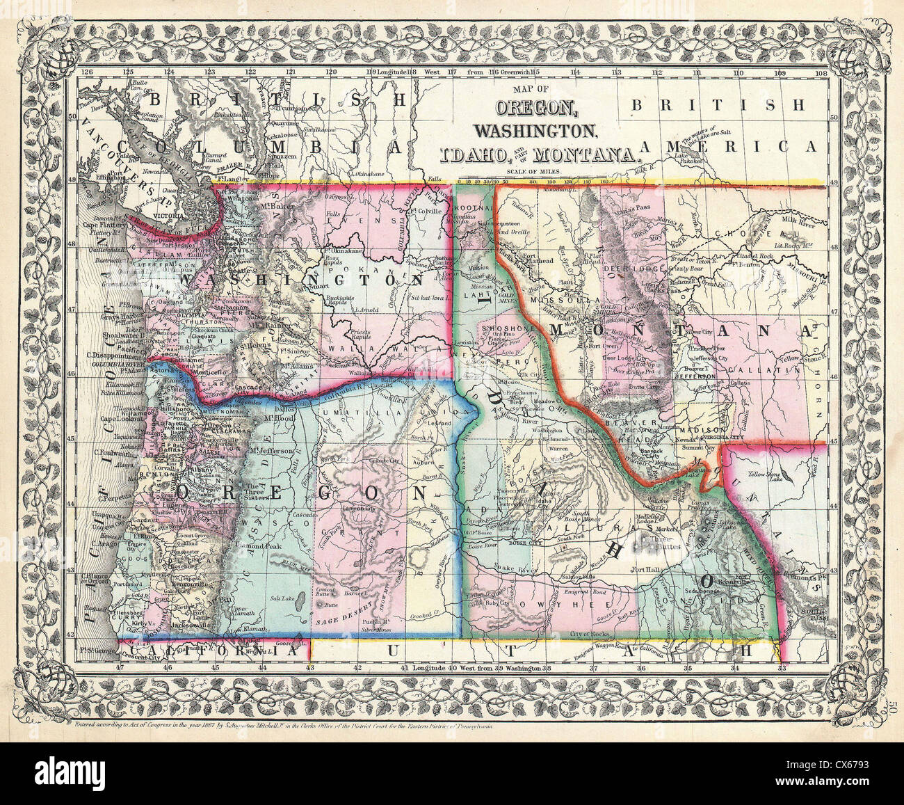
Look at a map. Really look at it. If you squint at the Idaho and Montana map, it looks like two puzzle pieces that were forced together by someone who didn’t have the instructions. Montana is massive, sprawling, and jagged on its left side. Idaho looks like a chimney or, as some locals joke, a face peering into Montana’s business.
There is a reason the line between these two states looks like a jagged staircase cut by a drunk carpenter.
The "Wrong" Border and the Great Surveyor Myth
You’ve probably heard the story. People love to tell it over a beer in Missoula or Boise. The legend says a group of surveyors in the 1860s got absolutely hammered on whiskey, lost their way in the mountains, and accidentally drew the line in the wrong place.
Honestly? It’s a great story. It’s also completely fake.
The real reason Idaho has that skinny northern panhandle and Montana has all those extra mountain ranges comes down to a guy named Sidney Edgerton. He was the Chief Justice of the Idaho Territory back when Idaho was a giant blob that included all of Montana and Wyoming.
Edgerton realized there was a ton of gold in the eastern part of the territory (what we now call Montana). He didn't want to govern that from Lewiston, Idaho, which was a nightmare to reach across the mountains. So, he went to D.C. with a bag of gold nuggets to lobby for a new territory.
He convinced Congress to move the border west of the Continental Divide. Originally, the "logical" border was supposed to be the spine of the Rockies. Instead, Edgerton pushed it to the Bitterroot Mountains. This move effectively stole millions of acres from Idaho and gave them to Montana. Idaho's legislature was basically "asleep at the switch" and didn't even know they'd lost the land until the deal was signed.
Talk about a bad day at the office.
Navigating the Map: Highways and High Passes
When you're driving an Idaho and Montana map route, you aren't just crossing a line; you're crossing some of the most intense terrain in the Lower 48. There are only a handful of ways to get from one to the other without a pack mule.
- Interstate 90 (Lookout Pass): This is the big one. It connects Coeur d’Alene, ID, to Missoula, MT. It’s the highest point on I-90 and can be a death trap in January.
- Highway 12 (Lolo Pass): This follows the route Lewis and Clark took. It is winding, gorgeous, and has almost zero cell service for 100 miles.
- Highway 93 (Lost Trail Pass): This takes you from the Salmon River country in Idaho into the Bitterroot Valley of Montana.
The geography here is dominated by the Bitterroot Range. These mountains aren't just pretty backdrops. They are 10,000-foot walls of granite. Trapper Peak is the king of the range at 10,157 feet. If you look at the map, you’ll see the border follows the "crest" of these mountains. This sounds simple until you realize a "crest" in the Rockies is a jagged, zig-zagging mess of ridges.
The Geography of the Panhandle
Idaho’s panhandle is only about 45 miles wide at the Canadian border. It’s tiny. But inside that sliver on the map, you’ve got Lake Pend Oreille, which is over 1,100 feet deep. The U.S. Navy actually uses it to test submarines because it’s so deep and quiet.
Montana, on the other hand, just keeps going. Once you cross east of the mountains on the map, the terrain flattens into the "Big Sky" plains, but the western third—the part that "belongs" to Idaho in a parallel universe—is all vertical.
Shared Borders and National Treasures
The map gets really messy around the southeast corner of Idaho. Most people think Yellowstone National Park is purely a Montana and Wyoming thing. Nope.
If you look closely at the Idaho and Montana map near the town of West Yellowstone, there’s a tiny sliver of the park that sits inside Idaho. It’s barely a few miles wide, but it’s there. This area was once part of "Lost Dakota"—a weird administrative oversight where a piece of land wasn't officially part of any territory for a while.
Then you have the Selway-Bitterroot Wilderness. This is one of the largest protected areas in the country, spanning over 1.3 million acres across both states. On a map, it looks like a giant green void. In reality, it's a place where there are no roads, no buildings, and more elk than people.
Mapping Your Next Move
If you're planning to explore the space between these two states, don't just trust a digital GPS. Those mountains eat satellite signals for breakfast.
- Get a physical Benchmarking Road Atlas. Digital maps often fail to show the forest service roads that actually connect these mountain towns.
- Check the "Snotel" sites. If you are crossing the border via Lolo or Lookout Pass between October and May, look up the Snotel (Snow Telemetry) data. A "clear" map in the valley means nothing when there's six feet of snow on the pass.
- Visit the "Big Burn" sites. Around the town of Wallace, ID (right on the border), the map is marked by the history of the 1910 fire. You can still see the scars on the landscape where 3 million acres burned across both states in two days.
The Idaho and Montana map isn't just a drawing of two states; it's a record of gold rushes, political backstabbing, and some of the most rugged geography on the planet. Whether you're looking for the deep waters of the Panhandle or the high peaks of the Bitterroots, that jagged border line is where the real adventure usually starts.
Next Step: Download the Avenza Maps app and grab the specific USFS (United States Forest Service) quads for the Lolo National Forest and Idaho Panhandle National Forests. These maps provide the granular detail on trailheads and seasonal gates that standard Google Maps will miss entirely.