You’ve probably seen the classic postcard version of California. It’s usually a sun-drenched shot of a palm tree leaning over a beach in Santa Monica or maybe the Bixby Creek Bridge in Big Sur. But if you actually sit down and look at a map of the California coastal cities, you realize the state is a massive, weird, and incredibly diverse beast. We are talking about roughly 840 miles of coastline. That is a lot of ground to cover.
Most people think of "coastal California" as one long, continuous beach party. It isn't. Not even close. If you drive from the Oregon border down to Mexico, you’re basically traveling through three or four different countries, climate-wise. You've got the misty, prehistoric-looking redwood forests in the north and the high-end, manicured Mediterranean vibes of Orange County in the south.
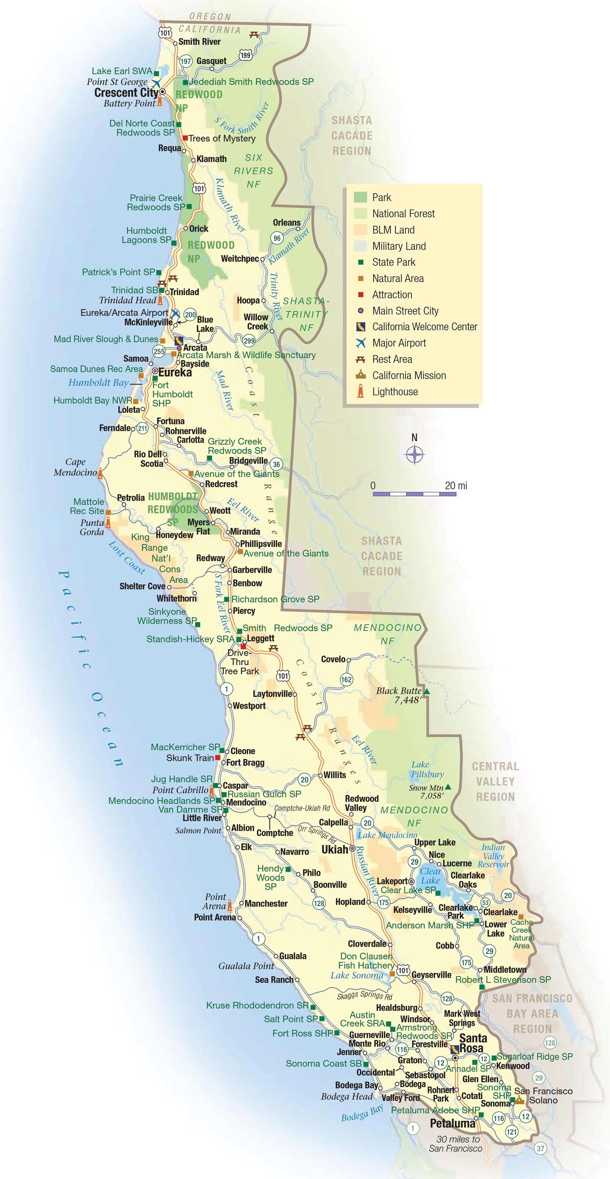
The North Coast: Where the Map Gets Wild
Let’s start at the top. Most travelers completely ignore the North Coast because it’s hard to get to. Honestly, that’s their loss. When you look at the map of the California coastal cities above San Francisco, the names aren't nearly as famous as Malibu or Laguna. You’re looking at places like Crescent City and Eureka.
Crescent City is basically the last stop before you hit Oregon. It’s rugged. It’s wet. It’s where the Redwoods meet the sea. You aren’t going there to tan; you’re going there to feel small next to trees that have been alive since the Roman Empire.
Further down, you hit Eureka and Arcata. These are "cities" by North Coast standards, but they feel more like Victorian timber towns. Eureka has some of the most insane Queen Anne-style architecture you’ll ever see, specifically the Carson Mansion. It’s a bit moody up there. The "Lost Coast" in Humboldt County is called that because the terrain was too jagged for engineers to even build Highway 1 through it. The road literally has to turn inland because the cliffs are too steep.
Small Towns You’ll Actually Love
- Fort Bragg: Famous for Glass Beach, where the ocean turned old trash into smooth sea glass.
- Mendocino: It looks exactly like a New England fishing village. Fun fact: It often doubled for Maine in the show Murder, She Wrote.
- Bodega Bay: This is where Alfred Hitchcock filmed The Birds. It’s still got that eerie, beautiful fog that rolls in every afternoon.
The San Francisco Bay and the Central Coast Shift
Once you cross the Golden Gate Bridge, the vibe shifts. San Francisco is the obvious anchor here, but the coastal map starts to get crowded. You’ve got Pacifica, which is a surfer’s haven, and Half Moon Bay, famous for the Mavericks big-wave surf contest.
But the real magic of the map of the California coastal cities happens as you head south into the Central Coast. This is the California people dream about.
Santa Cruz is the gateway. It’s a mix of old-school hippie culture, University of California students, and tech commuters. The Beach Boardwalk is a classic, but the real soul of the city is in the surf breaks like Steamer Lane.
The Monterey Peninsula
Just across the bay is Monterey and Carmel-by-the-Sea. Monterey used to be the sardine capital of the world (read some John Steinbeck if you want the gritty history), but now it’s home to one of the best aquariums on the planet. Carmel is... well, it’s fancy. There are no street addresses in Carmel-by-the-Sea. People go to the post office to get their mail. It’s that kind of place.
The Big Sur Gap
On any map of the California coastal cities, there’s a giant stretch of green and blue between Carmel and San Simeon. This is Big Sur.
It’s important to realize that Big Sur isn’t really a "city." It’s a region. There’s a post office, a few restaurants like Nepenthe, and a lot of state parks. Highway 1 here is legendary, but it’s also fragile. Landslides happen almost every winter. If you're planning a trip, check the Caltrans maps first. Seriously. You don't want to drive three hours only to find a "Road Closed" sign at Ragged Point.
The Central Coast: Santa Barbara and Beyond
Coming out of the mountains of Big Sur, you hit San Luis Obispo (SLO) County. This is where the pace slows down.
- San Simeon: Home to Hearst Castle. Publishing tycoon William Randolph Hearst built a Mediterranean revival palace on a hill, complete with zebras (some of their descendants still roam the fields nearby).
- Morro Bay: You can’t miss it because of Morro Rock, a 576-foot volcanic plug sitting right in the harbor.
- Pismo Beach: It’s one of the few places you can actually drive your truck onto the dunes.
Then you hit Santa Barbara. They call it the "American Riviera" for a reason. The city has strict building codes—almost everything is white stucco with red tile roofs. It sits on a south-facing stretch of coast, which means the sun hits it differently than anywhere else in the state. It feels expensive because it is.
The South Coast: The Megacity Map
When you look at the map of the California coastal cities in the south, the lines between towns start to blur. It’s basically one giant metropolitan area from Ventura all the way to the border.
Malibu is the first major stop as you enter Los Angeles County. It’s 27 miles of scenic beauty, mostly tucked behind gated driveways. Then you hit Santa Monica and Venice. Santa Monica is the polished, tourist-friendly version of the beach, while Venice is... well, Venice is a circus. It’s loud, it’s colorful, and it’s arguably the best people-watching spot in the country.
The "South Bay" Cities
South of LAX, you hit the "Beach Cities":
- Manhattan Beach: High-end homes and professional volleyball.
- Hermosa Beach: A bit more of a party vibe with a great pier.
- Redondo Beach: Known for its horseshoe-shaped pier and fresh seafood.
Orange County and San Diego
Orange County (OC) is where the "Surf City" mythos really lives. Huntington Beach literally trademarked the name. Further south, Newport Beach is all about yacht culture and the Balboa Island Ferry.
Laguna Beach is the crown jewel of the OC coast. It’s built into steep canyons and has tiny, hidden coves like Thousand Steps Beach. It’s incredibly picturesque, but parking is a nightmare in the summer. Just a heads up.
Finally, the map ends in San Diego. This is a massive Navy town, but it’s also a collection of distinct beach neighborhoods. La Jolla is where you find the sea lions and upscale boutiques. Pacific Beach is where the college crowd hangs out. Coronado is home to the famous Hotel del Coronado, a wooden Victorian masterpiece.
What the Map Doesn't Tell You
Maps are great for directions, but they suck at explaining reality. Here are a few things you won't see on a standard map of the California coastal cities:
- The "June Gloom": In May and June, the coast is often covered in a thick layer of marine clouds. You might go to the beach in Malibu expecting a tan and end up shivering in a hoodie.
- The Water Temperature: This isn't Florida. The California Current brings cold water down from Alaska. Even in San Diego, the water rarely gets above 70 degrees without a wetsuit.
- Traffic is a Variable: On a map, Santa Monica to Malibu looks like a 20-minute drive. On a Friday afternoon in July? That’s 90 minutes of your life you aren't getting back.
Actionable Tips for Navigating the Coast
If you are actually planning to use a map of the California coastal cities to plot a road trip, don't try to do it all at once. Pick a region.
The "Northern Nature" Route
Start in San Francisco and head north to Eureka. Focus on the redwoods, the oysters in Tomales Bay, and the quiet of the Sonoma coast. You’ll need a sturdy car and a raincoat.
The "Classic Central" Route
Fly into San Jose, drive down to Santa Cruz, and follow Highway 1 through Monterey, Big Sur, and down to Santa Barbara. This is the "greatest hits" tour. Give yourself at least four days for this stretch alone.
The "Southern Sun" Route
Start in Santa Barbara and end in San Diego. This is the best route for families who want piers, theme parks (like the San Diego Zoo), and consistent sunshine.
Practical Next Steps
- Check Road Conditions: Use the Caltrans QuickMap to see if Highway 1 is actually open.
- Download Offline Maps: Cell service in Big Sur and the North Coast is non-existent. Download your Google Maps area before you leave the hotel.
- Book Big Sur Early: If you want to stay in a yurt or a lodge in Big Sur, you often need to book 6 months in advance.
- Layers are King: Even in the south, the temperature drops 20 degrees the second the sun goes down over the Pacific. Bring a jacket.