You’re standing on your porch. The air feels heavy, humid, and weirdly still. Overhead, the sky isn't just gray—it’s a bruised, sickly shade of olive green. You see a massive, rotating wall of vapor descending like a slow-motion weight. This is the moment people realize they don't actually know which clouds form tornadoes until they're staring one in the face. It isn't just any rain cloud. Most people point at a dark sky and think "tornado weather," but the reality is a lot more specific and, frankly, a lot more terrifying.
Tornadoes don't just drop out of thin air. They are the final, violent act of a very specific atmospheric drama.
The Supercell: The King of Tornado Clouds
If you want to know which clouds form tornadoes, you have to start with the Supercell. This isn't your average afternoon thunderstorm that rains on your barbecue for twenty minutes and then vanishes. A supercell is a monster. It’s a long-lived, highly organized thunderstorm characterized by a deep, persistently rotating updraft called a mesocyclone.
Think of a supercell as a giant engine. It sucks up warm, moist air from the ground (the fuel) and pushes it miles into the atmosphere. Most thunderstorms have multiple "cells" that compete for energy. A supercell is a lone wolf. It dominates the sky, sometimes stretching 50,000 feet into the air. When you see those massive, anvil-topped giants that look like they’re made of sculpted marble, you’re looking at the primary factory for a tornado.
The Cumulonimbus Parent
Technically, every tornado comes from a Cumulonimbus cloud. These are the "thunderheads." However, a garden-variety cumulonimbus will just give you a heavy downpour and maybe some lightning. For a tornado, you need that cloud to be "tornadic," which happens when wind shear enters the mix. Wind shear is basically the wind changing speed and direction at different heights. It starts the air rolling horizontally, like a pencil rolling on a table. Then, the powerful updraft of the cumulonimbus tips that rolling air vertical.
Now the whole cloud is spinning.
The Wall Cloud: The Danger Zone
If the supercell is the factory, the Wall Cloud is the assembly line. This is probably the most important visual cue for anyone on the ground. When a supercell is maturing, a localized lowering occurs beneath the rain-free base of the storm.
It looks like a pedestal. Or a heavy, dark block hanging down from the main cloud body.
This happens because the storm's updraft is sucking up air that has been cooled by rain. This cool, moist air condenses at a lower altitude than the rest of the storm. When you see a wall cloud, you are looking at the exact spot where a tornado is most likely to form. But here is the kicker: it has to rotate. A wall cloud that isn't spinning is just a scary-looking cloud. A wall cloud that is spinning like a slow top? That’s when you get underground.
Recognizing the "Beaver’s Tail" and Inflow Bands
Experienced storm spotters look for "inflow bands." These are long, low-hanging streamers of clouds that seem to be getting sucked into the wall cloud. One specific type is called a Beaver’s Tail. It’s a broad, flat cloud band that looks exactly like its namesake, extending out toward the east or northeast. It shows that the storm is "breathing" efficiently, pulling in huge amounts of moisture to fuel its rotation.
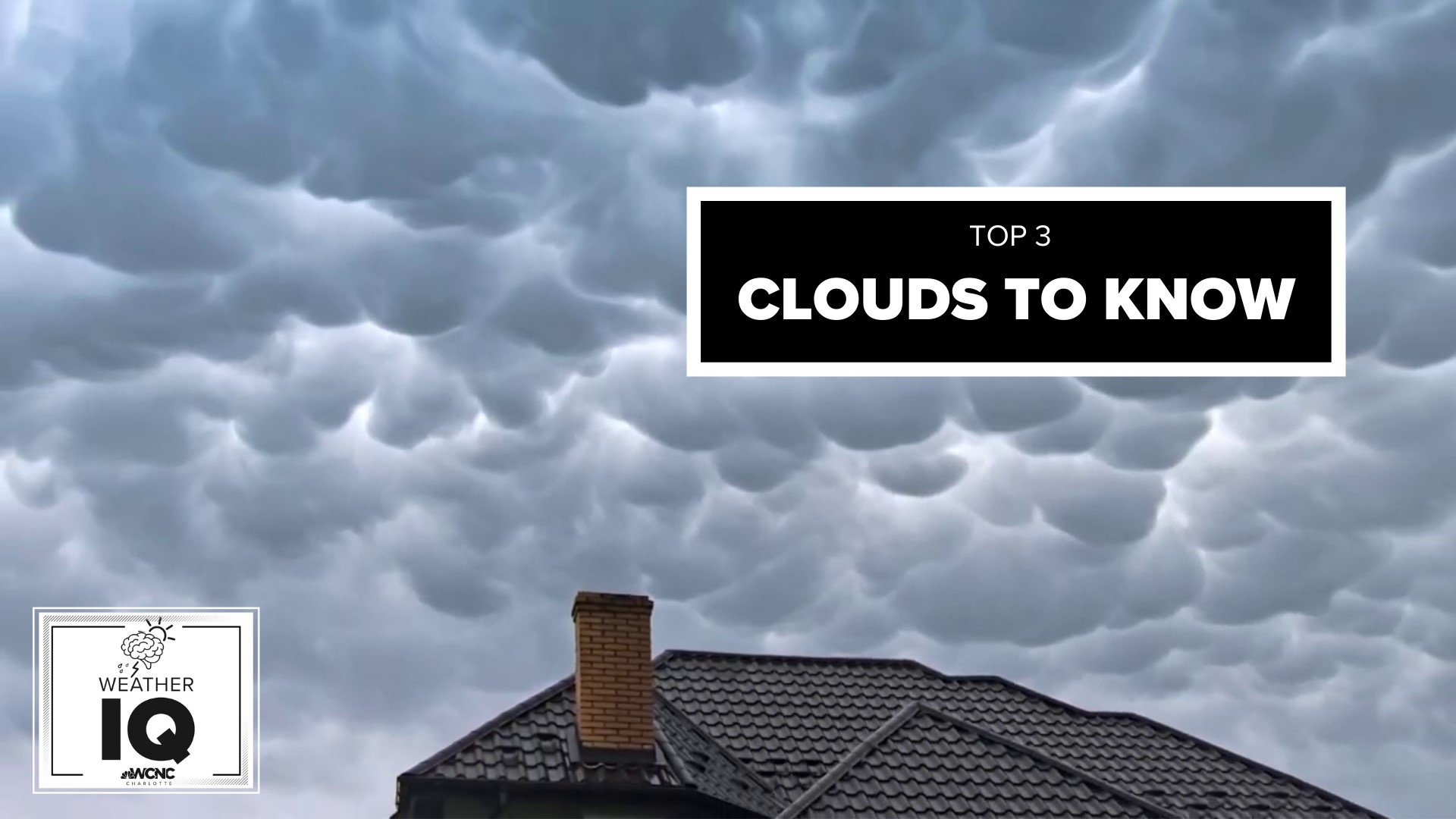
The Misunderstood Mammatus
You’ve seen the photos. They look like bubbles, or pouches, or even breasts (which is actually where the name comes from). Mammatus clouds are perhaps the most photographed "scary" clouds in existence. They often appear on the underside of the anvil—the flat top—of a thunderstorm.
Here’s the thing: Mammatus clouds do not form tornadoes.
Honestly, they usually show up when the worst of the storm is actually over or passing by. They are a sign of extreme turbulence and sinking air, but they aren't the funnel. They are the "exhaust" of the storm. If you see them, the atmosphere is definitely unstable, but you’re likely looking at the rear of the storm or the edges. They’re beautiful, eerie, and a favorite for Instagram, but they aren't the primary answer to which clouds form tornadoes.
Funnel Clouds vs. Tornadoes
It sounds like a semantics game, but it matters. A funnel cloud is a rotating cone of condensed water droplets. It’s "the cloud" part. However, it isn't a tornado until it makes contact with the ground or causes debris to fly at the surface.
Sometimes you can have a tornado on the ground—doing damage, lifting roofs—while the "funnel" cloud only looks like it's halfway down. This happens because the invisible vortex of wind has reached the ground, but the pressure hasn't dropped enough yet to cause the water vapor to condense all the way down. If you see a rotating "dust whirl" on the ground under a wall cloud, even if there's no visible funnel connecting them, that is a tornado.
Non-Supercell Tornadoes: The Landspouts
Not every tornado is a heavy-hitter from a supercell. There are "landspouts." These come from much smaller, less organized clouds, often simple Cumulus Congestus clouds.
These clouds are just growing, puffy white towers. They don't have a mesocyclone. Instead, a landspout forms when there is already a small whirlpool of air on the ground (maybe from a boundary where two winds meet), and a growing cumulus cloud passes over it. The cloud's updraft stretches that small whirl upward, tightening it into a thin, rope-like tornado. They are usually weaker, but they can still flip a trailer or tear up a roof.
Shelf Clouds: The Great Pretender
People constantly mistake Shelf Clouds for tornadoes or wall clouds. A shelf cloud is a long, wedge-shaped cloud that appears on the leading edge of a storm. It looks like a giant wave or a shelf (hence the name).
While a wall cloud is associated with the updraft (air going up), a shelf cloud is associated with the downdraft (air coming down). As the rain-cooled air crashes to the ground, it spreads out, pushing the warm air in front of it upward. This creates the shelf. Shelf clouds look terrifying, like a wall of doom moving toward your house, but they generally bring straight-line winds and heavy rain, not tornadoes.
Actionable Steps for Storm Season
Understanding which clouds form tornadoes is your first line of defense. If you're out in the field or just looking out your kitchen window, here is how you should process what you're seeing:
- Check the Base: Look at the bottom of the storm. Is it flat and high, or is there a specific, lower "block" hanging down? If there is a lower block (a wall cloud), watch it closely.
- Look for Rotation: This is the deal-breaker. Take a fixed point—like a tree or a pole—and compare the cloud's movement against it. If the cloud is moving horizontally across the sky, that’s just wind. If the cloud is "rolling" or "spinning" around a vertical axis, that is a precursor to a tornado.
- Identify the Inflow: Are clouds being sucked into the main storm base? If you see "scud" clouds (jagged, low-hanging cloud bits) being pulled upward and into a rotating wall cloud, the storm is intensifying.
- Don't be Fooled by the Shelf: If a long, linear cloud is rushing toward you with a "whale's mouth" appearance behind it, prepare for high winds and rain. It’s likely a shelf cloud, which means the "outflow" is hitting you, not a tornado.
- Listen to the "Freight Train": It’s a cliché for a reason. If you see a rotating wall cloud and then hear a low, continuous rumble that sounds like a jet engine or a train—and it’s not thunder—the tornado has likely already touched down.
The most dangerous part of a tornadic storm is often wrapped in rain. "Rain-wrapped" tornadoes are hidden behind a curtain of heavy precipitation, making them invisible until they are right on top of you. In these cases, your eyes will fail you. Rely on a NOAA weather radio or a high-quality radar app that shows "Velocity" data. Velocity radar shows air moving toward and away from the radar site; when you see bright red and bright green colors right next to each other (a couplet), that’s the rotation inside the cloud, even if you can't see it through the rain.
Stay weather-aware. When the sky turns that specific, haunting shade of green, and the clouds start moving in circles rather than straight lines, the atmosphere is no longer just "stormy"—it’s dangerous.