Look at any map of the Rhine River and you’ll see a blue vein pulsing through the heart of Europe. It looks simple enough. It starts in the Swiss Alps, curls through Lake Constance, forms the border between France and Germany, and finally spills out into the North Sea at Rotterdam. But that blue line is a liar. It doesn't show you the centuries of engineering, the political bickering, or the fact that the river’s length actually changed because someone did the math wrong back in the 1960s.
The Rhine is 1,233 kilometers long. Or is it? For decades, textbooks said 1,320 kilometers. It wasn't until a researcher named Bruno Kremer noticed the discrepancy in 2010 that the official records were updated. This isn't just a fun trivia fact; it matters for navigation, for environmental data, and for the millions of people who live along its banks. When you're looking at a map of the Rhine River, you’re looking at one of the most heavily trafficked waterways in the world, a liquid highway that carries everything from coal to river cruisers.
The Alpine Start: Where the Blue Line Begins
Most people think the Rhine starts at a single spring. It doesn't. It’s a messy, cold, and beautiful collection of streams in the Swiss canton of Graubünden. The Vorderrhein and Hinterrhein meet at Reichenau, and only then do we officially call it the Rhine. If you're hiking the "Source of the Rhine" trail near Lake Toma, you're at 2,345 meters above sea level. It’s quiet there.
Then it hits Lake Constance (the Bodensee). This is a massive "balancing tank" for the river. The water enters sediment-heavy and leaves crystal clear. Geographically, this section is a headache for cartographers. Why? Because there are no official borders in the middle of the main part of Lake Constance. Switzerland, Germany, and Austria just sort of agree to disagree on where the lines are drawn. If you're looking at a map of the Rhine River in this region, the borders often just... disappear once they hit the water.
The High Rhine vs. The Upper Rhine
Once the water leaves the lake, it heads west toward Basel. This is the High Rhine. It’s famous for the Rhine Falls at Schaffhausen. It’s the largest plain waterfall in Europe. Don't expect Niagara-level heights, but the sheer volume of water is terrifying.
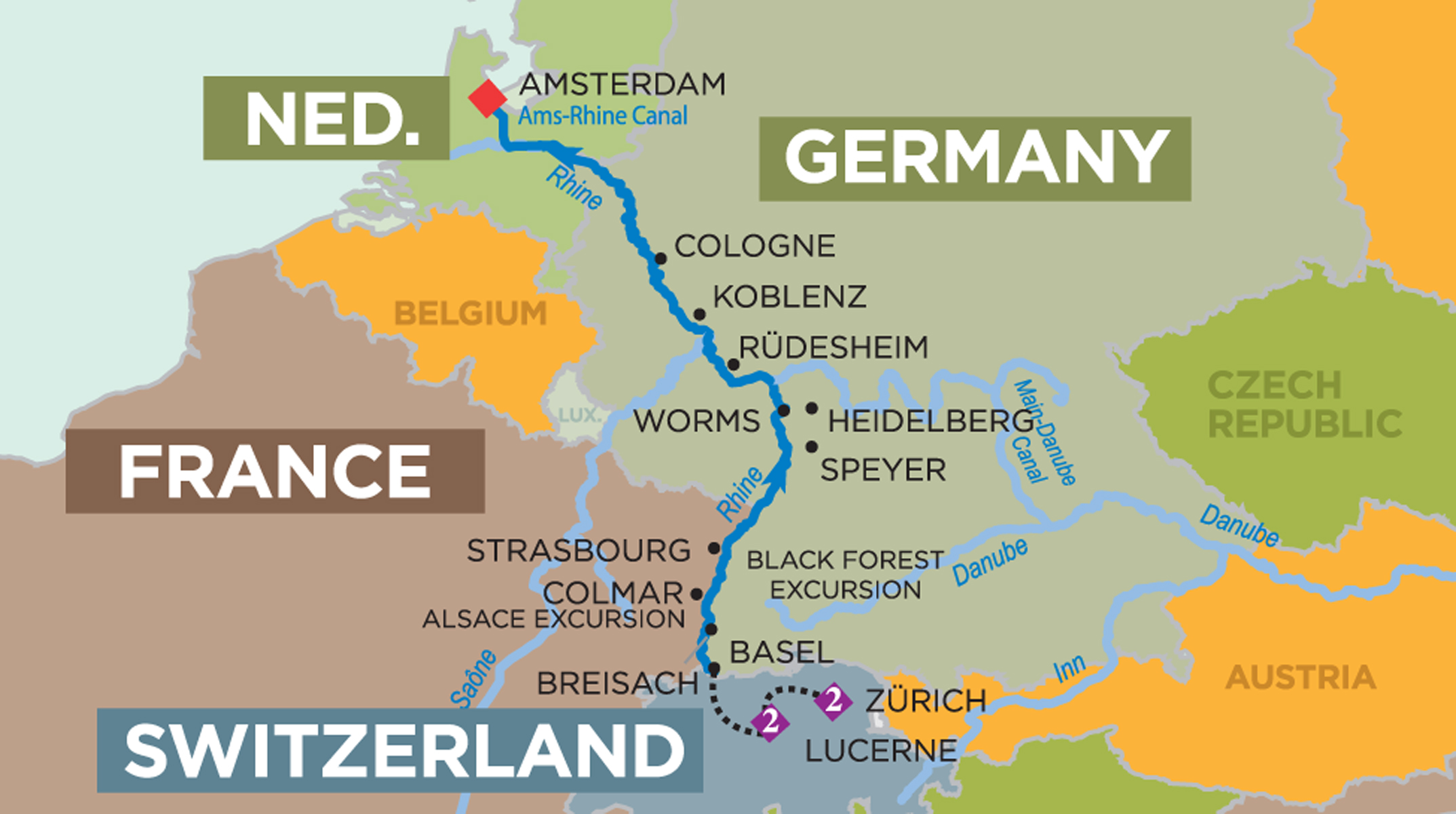
At Basel, the river takes a sharp right turn. It heads north. This "Rhine Knee" marks the start of the Upper Rhine. This is the section that flows through the Rhine Rift Valley. Historically, this part of the river was a swampy, braided mess. It shifted constantly. Farmers would wake up and find their land was suddenly on the other side of the river. In the 19th century, an engineer named Johann Gottfried Tulla decided to "tame" it. He straightened the river to make it navigable and to stop the flooding. He shortened the Upper Rhine by about 80 kilometers. It was an engineering marvel, but a disaster for local biodiversity.
Navigating the Middle Rhine: The Romantic Map
When most tourists search for a map of the Rhine River, this is what they want. The Rhine Gorge. The stretch between Bingen and Koblenz. It’s a UNESCO World Heritage site for a reason. You’ve got more castles per mile here than anywhere else on earth. Marksburg, Stahleck, Pfalzgrafenstein—the names sound like something out of a fantasy novel.
The Lorelei rock is the centerpiece. It’s a narrow, deep bend where the current is incredibly strong. Legend says a siren sat there combing her hair and luring sailors to their deaths. The reality? A rocky reef and a treacherous turn created a natural acoustic echo that sounded like whispering. Even today, with modern GPS and powerful engines, captains take this turn with a lot of respect.
- The Binger Loch: A narrow passage near Bingen that was once so rocky it blocked most ships. It was blasted open in the 19th century.
- The Nahe Mouth: Where the Nahe River flows into the Rhine, creating a distinct color contrast in the water.
- Vineyards: The steep slate slopes of the Rheingau and Mittelrhein produce some of the world's best Rieslings. The "map" here isn't just about water; it's about terroir.
The Industrial Powerhouse: Lower Rhine and the Delta
As the river flows past Bonn and Cologne, the scenery changes. The castles disappear. In their place come the massive industrial hubs of the Ruhr area. This is the engine room of Europe. Duisburg-Ruhrort is the largest inland port in the world. When you see a map of the Rhine River marked with industrial icons, you’re looking at the reason Germany became an economic superpower.
The river is deep here. It’s wide. It carries massive barges, some over 100 meters long, filled with iron ore and containers. But then comes the Dutch border.
The Rhine enters the Netherlands and immediately has an identity crisis. It splits. First into the Waal and the Nederrijn. Then the IJssel branches off toward the north. The "Rhine" name actually stays with a relatively small branch (the Oude Rijn), while the bulk of the water flows through the Waal toward Rotterdam. If you’re trying to follow a map of the Rhine River to the sea, it’s easy to get lost in the Delta. The Dutch have spent centuries building dikes and storm surge barriers (like the Maeslantkering) to keep this water from swallowing their country.
Why the Map Keeps Changing
Climate change is rewriting the map of the Rhine River in real-time. In 2018 and 2022, the water levels dropped so low that the "Hunger Stones" were revealed. These are carved rocks in the riverbed that only appear during extreme droughts, historically marking years of famine.
Low water is a nightmare for the economy. When the levels at the Kaub gauge—the shallowest part of the Middle Rhine—drop below 40 centimeters, most large barges can only carry a fraction of their cargo. Some can't pass at all. We are seeing a shift in how the river is mapped, with "digital twins" now being used to predict water flow and sedimentation down to the centimeter.
Logistics and the "New" Rhine
Because of these low-water events, companies like BASF and ThyssenKrupp are commissioning ships designed specifically for shallow water. They are literally re-mapping the limits of what a river vessel can do. A modern map of the Rhine River for a ship captain isn't a piece of paper; it’s a live data feed showing real-time depths at the Binger Loch and the Lorelei.
Critical Spots on Your Rhine Map
If you're planning a trip or studying the geography, these aren't just coordinates. They are the "greatest hits" of the river's 1,200-kilometer journey.
- The Tomasee (Switzerland): The symbolic source. It’s a hike, not a drive.
- Lake Constance (Germany/Switzerland/Austria): A vast inland sea that regulates the Rhine's flow.
- The Rhine Falls (Switzerland): Power and noise.
- The Deutsches Eck (Germany): In Koblenz, where the Moselle meets the Rhine. There’s a massive statue of Kaiser Wilhelm I. It’s the ultimate photo op.
- Cologne Cathedral: The river flows right past this gothic masterpiece. It’s been a landmark for Rhine travelers for 800 years.
- The Port of Rotterdam (Netherlands): Where the journey ends. It’s a labyrinth of steel and cranes.
How to Read a Rhine Map Like a Local
Don't just look at the blue line. Look at the "Kilometer-stones." Every kilometer along the Rhine is marked with a sign on the bank. The numbering starts at the bridge in Konstanz (Kilometer 0) and goes all the way to the Hook of Holland (Kilometer 1032).
Wait, didn't I say the river was 1,233 kilometers long?
Yes. But the "Navigable Rhine" uses its own numbering system. This is what you'll see on a professional map of the Rhine River. If you’re on a cruise and the captain says you’re at "Kilometer 555," you’re exactly at the Lorelei.
Actionable Insights for the Modern Traveler or Researcher
If you are looking for a map of the Rhine River to plan a journey or understand the region, keep these practical points in mind:
- Check the Gauges: For real-time data on whether the river is navigable or if your cruise might be bused, use the ELWIS (Electronic Waterway Information Service) portal. It’s the gold standard for Rhine water levels.
- The "KD" Map: The Köln-Düsseldorfer (KD) line has been running ships on the Rhine for nearly 200 years. Their maps are geared toward the "Romantic Rhine" and highlight every castle and vineyard.
- Satellite vs. Topographic: Use satellite imagery to see the "sediment plumes" where tributaries like the Main and Moselle join the Rhine. It’s a striking visual of how different water bodies mix.
- The Delta Dilemma: If you’re exploring the mouth of the river, look for maps of the "Rhine-Meuse-Scheldt delta." The Rhine doesn't end in a single mouth; it ends in a massive, complex network of canals and distributaries.
Understanding the map of the Rhine River means understanding the history of Europe itself. It’s a border that unites rather than divides. It’s a managed ecosystem that is currently struggling with a changing climate. And honestly, it’s just a beautiful place to spend a week on a boat, watching the castles go by while sipping a glass of Riesling.
To get the most out of your research, download a high-resolution topographic map that shows elevation. You’ll see exactly why the river carves through the Rhenish Massif in the middle section—it’s the only way through the mountains. That "cut" is what created the Rhine Gorge and changed the course of European trade forever.